Tuesday, February 7, 2023

South Quay Surprise

07 Feb 23:

We are doing some maritime research for Colonial Virginia during the 18th Century. One of the first things we came across was a seaport and shipyard at South Quay, established in 1657, one of the busiest in the area. Located on the Blackwater River near the Virginia-North Carolina border, the port there provided a protected spot for Colonial goods to flow in and out of the region of southside Virginia.


What surprised us was that large 3 masted schooners could make their way 120 miles from the Atlantic, through Albemarle Sound, up the Chowan River and into the Blackwater. Back in the day you could hop onboard get a non stop ride to England. If we were to go to this spot today, we might be lucky to drag a kayak over downfall from riverbank vegetation. How did they navigate schooners drawing 8-9 feet up river? Well for one, the land nearby was still in its natural wooded state,  there had not been clear cutting of trees that created erosion of nearby soil. But moreso, colonists made great effort to keep the river clear of debris. 

There were two small American rowing galleys built there that played a role in the Revolution, the CASWELL and GENERAL WASHINGTON, denying the British access to the area for much of the war. They were well armed and well suited for close quarters combat in confined areas. For 5 years supplies streamed up river to buoy the American cause, and finally in 1781 British units under the command of Colonel Banastre Tarleton occupied South Quay and destroyed the buildings and shipyard. 

The buildings at the village were rebuilt but South Quay did not long remain an important shipping port for the region, as more seaports were established and trading highways expanded inland.

Saturday, February 4, 2023

Porcine Art

Another fun thing to do in Smithfield, visit our porcine art.

https://www.smithfield2020.org/porcine-parade.html

Magnolia  - Artist: Lois Chapman Location: Isle of Wight County Museum 

Like her namesake tree known for its beautiful flowers, Magnolia shows her beauty through photographs and maps from the Isle of Wight County Museum's collection to detail the community's rich history. Dressed as a porcine scrapbook, Magnolia offers the viewer a chance to see the elements which make this area unique.


Mason (Windsor Castle Pork) - Artist: Cil Barbour 
Location: Mason Street entrance to Windsor Castle Park 

This pig offers visitors a glimpse of the many activities and elements featured at Windsor Castle Park. Fishing, kayaking, canoeing, scenic woodland trails, open spaces, a natural amphitheater and the historic home enhance this 209-acre riverside park.


Helen Haverty King

04 Feb 23:

Helen Haverty King compiled an enormous amount of research on the local area, supplemented with a nice map.

https://www.amazon.com/Books-Helen-Haverty-King/s?rh=n%3A283155%2Cp_27%3AHelen+Haverty+King

Friday, February 3, 2023

Trading Towns and Ports 1680 and 1708

03 Feb 23:

"In 1680, places were selected in the different counties that had the advantage of accessibility and deep water where ships could gather to receive and discharge their cargoes. The establishment of these trading towns, as they were called, was by an Act as follows:

The General Assembly having taken into consideration the great necessity, usefulness and advantages of cohabitation … and considering the building of storehouses for the reception of all merchandizes imported, and receiving and laying ready all tobacco for exportation and sale … that there be in every respective county fifty acres of land purchased by each county and laid out for a town and storehouses….

The price of the fifty acres of land was set at 10,000 pounds of tobacco and casks. Lots of one-half acre were to be sold to individuals by a stated time at the price of one hundred pounds of tobacco. Twenty places were named in the counties where trading towns were to be established:

Henrico, at Varina. Charles City, at Flower de Hundred opposite Swinyards. Surry, at Smith's fort. James City, at James City. Isle of Wight, at Pate's Field, Pagan creek. Nansemond, at Huff's point. Warwick, at the mouth of Deep creek. Elizabeth City, west side of Hampton river. Lower Norfolk, on Nicholas Wise's land. York, on Mr. Reed's land. New Kent, at the Brick House. Gloucester, at Tindal's point. Middlesex, west side of Wormley's creek. Rappahannock, at Hobb's hole. Stafford, at Peace point. Westmoreland, at Nomini. Accomack, at Onancock. Northampton, north side of King's creek. Lancaster, north side of Corotomond creek. Northumberland, at Chickacone creek.

The towns were building up. Warehouses, churches, and prisons were erected in many of them, as well as private dwellings. An occasional court house could be found where legal proceedings were enacted. In 1691, however, an Act of the General Assembly changed many of the trading towns to ports, but was suspended later until the pleasure of the King and Queen on the subject should be learned. No definite action was taken until 1705, when Queen Anne, who ascended the throne in 1702, expressed approval. Then an Act for ports of entry and clearance was passed to be in use from the 25th of December, 1708. This Act provided that naval officers and collectors at the ports should charge Virginia owners of vessels no more than half of the fees required for the services of entering and clearing. The sixteen towns to become ports were named as follows:

Hampton. Norfolk. Nansemond. James City. Powhatan (Flower de Hundred). Yorktown. Queensborough, at Blackwater. Delaware, at West Point. Queenstown, at Corrotoman. Urbanna, at Middlesex. Tappahannock, at Hobb's hole. New Castle, at Wicomico. Kingsdale, at Yohocomoco. Marlborough, at Potomac creek. Northampton, at King's creek. Onancock."

Reference: 

Evans, Cerinda W..Some Notes on Shipbuilding in Colonial Virginia. Mariners Museum, 1957

Wednesday, February 1, 2023

Rivers, Streams, Creeks and Swamps

 01 Feb 23:

A nice compilation of waterways in our new locale, with GPS coordinates: 

Top Streams in Isle of Wight County, Virginia

We have quite a few places to muck about in our new area, who knew there were so many creeks and swamps out here? We've been on Burwell's Bay, James River a few times, and there are ramps nearby for three of the creeks on the list, which lead into some of the other creeks. Maybe we can check out all of them, but the last on the list are Rattlesnake Swamp and Tormentor Creek.

We'll be watching the tide chart!

Cypress Creek near Smithfield Station.

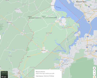
One interesting part of our research, in the early 1800s there were proposals to connect the top of the Pagan River with the inland Blackwater River that runs down the County's western border, using a canal. This would have connected inland trade to both the James River and down the Blackwater-Chowan to Albermarle Sound. They only needed 10 miles of canal to do it, but it never happened. Had they done so, they would have made this part of SE Virginia and NE North Carolina an Island. A few decades later the railroads started laying track everywhere and waterway trade began to dry up.

Pagan River - Blackwater River Canal